
Winning annexation battles to preserve homes, community and environment is what CEDS helps people do anywhere in the U.S. To learn how CEDS can help you win you defeat a poorly planned propose to annex your property or adjacent land into a town, city or county contact CEDS at 410-654-3021 or Help@ceds.org today for an initial no-cost discussion of strategy options.
Click this text to see examples of CEDS annexation successes.
After learning the specifics of the proposal we can usually offer initial strategy suggestions for winning an annexation battle. Advice by phone is available free to those seeking to prevent annexation from harming a community or the environment. Please don’t hesitate. Delay almost always decreases the likelihood of success.
The CEDS Approach
Following is an introduction to the CEDS approach for winning annexation battles. We urge you to take a few moments and click: PowerPoint presentation. In this presentation we use annexations in our home state (Maryland) to illustrate how to win these battles.
With regard to the CEDS approach, there are two options for applying it to your effort.
- First, we can carry out this strategy for you.
- Second, you can implement the strategy on your own with the advice presented below and in our fact sheet: Annexation & Citizens: Assessing Quality of Life Impacts & Successful Strategies
Most Annexation Victories Are Political; Not Legal
Most folks who succeed in winning annexation battles do so through political action not just with legal action.
By political, we mean showing the local elected officials who are the final annexation decision-makers that large numbers of local voters share your position on the annexation. Guidance for mobilizing voter support is provided in the following CEDS webpage: https://ceds.org/mobilize/. However, an attorney may be essential to ensuring a decision to deny annexation withstands an appear by a disgruntled applicant.
We urge you to try talking with your local elected officials before hiring an annexation attorney. You will find advice on working with these officials in Chapter 39 of our free 300-page book, How To Win Land Development Issues.
If elected officials fail to quickly and fully resolve your annexation concerns then we urge you to mount an aggressive political campaign. Far too many citizens have lived to regret delaying action in hopes that a bad annexation would go away. When in doubt, please contact us immediately. We can give you an initial, no-cost opinion about whether its time to act. If you find you lack the time for this research then consider having CEDS conduct it for you through an Initial Strategy Analysis.
More detail regarding the annexation process is provided in our PowerPoint presentation and our fact sheet: Annexation & Citizens: Assessing Quality of Life Impacts & Successful Strategies.
The Annexation Process
Annexation is a process used to expand the boundaries of a town, city or county. Most annexations are motivated by an opportunity to develop land at higher densities or a desire to take land generating higher tax income into municipal boundaries.
Most towns and cities have a system of pipes for delivering purified water to each home or business and then carrying away wastewater to a treatment plant. Homes and businesses outside the municipal boundary must rely on wells and septic systems. Frequently health regulations prohibit putting more than one or two housing units on an acre of land served only by well and septic. But if connected to public water and sewer, 16 housing units or more might be developed on each acre.
The land to be annexed must be physically connected to the town or city boundaries though the connection may be nothing more than a road owned by the municipality. Depending upon which state you’re in, a minimum portion all the property owners or voters living within the proposed annexation area must agree to be annexed. To see how annexation works in your state go to: State-By-State Annexation Summary.
More details regarding the annexation process is provided in our PowerPoint presentation and our fact sheet: Annexation & Citizens: Assessing Quality of Life Impacts & Successful Strategies.
Good & Bad Annexations
Annexations should only occur once various studies show that it will enhance quality of life for existing and future residents. At a minimum, the studies should prove that the annexation will result in benefits that greatly outweigh any of the following negative effects:
- traffic congestion,
- school overcrowding,
- overuse of parks and other recreation facilities,
- tax increases,
- add to climate changing-greenhouse gas emissions,
- harm public health, or
- cause any other adverse effects.
The best annexations will result in quality of life improvements such as:
- better paying jobs,
- greater access to mass transit,
- more affordable housing,
- improved schools including reduced class sizes,
- a net positive increase in the tax base,
- enhanced environmental protection including restoration of degraded waterways,
- improved pedestrian and cycling facilities,
- and more.
Responsible annexation begins with a good comprehensive land use plan. Most towns, cities and counties have adopted plans that show how growth will be managed over the next decade or two. A really good plan will provide the following analysis for each growth factor (traffic, schools, etc.):
- Present quantifiable criteria for assessing the impact of growth on each quality of life factor likely to be affected by future development,
- Based on these criteria, show how past growth has affected each quality of life factor,
- Use the criteria to show how the effect will likely change with anticipated growth,
- Propose actions to prevent an undue decline in quality of life,
- Also propose actions to enhance existing quality of life, and
- Provide the factual basis for why the actions are likely to produce the benefits claimed in the plan, along with any uncertainty.
Examples of these criteria and results are presented in the CEDS webpage, Comprehensive Growth Plans: How Good Is Yours?
The CEDS Project Evaluation Checklist allows you to do a preliminary assessment of the quality of life effects of a proposed annexation.
Examples of assessing impacts is provided in the next section of this webpage for the four most common annexation adverse effects.
Further detail from CEDS for specific growth impacts and land uses will be found at: https://ceds.org/issues-we-can-help-you-win/
Also, see:
- Annexation Impact Assessment – Maryland Example, and
- Factsheet – Annexation & Citizens: Assessing Quality of Life Impacts & Successful Strategies.
If you wish, for a modest fee CEDS can conduct these analyses for you or hold a workshop on how you can run your own assessment.
Preventing Annexation Impacts
Following is a summary of the more common adverse effects that may result from a poorly planned annexation. Suggestions are offered for how to gain the benefits of a not so poorly planned annexation.
CEDS can assist you in evaluating the impact of a proposed annexation for the following adverse effects and others. The starting point in evaluating each impact category will usually be the general criteria described in the CEDS Comprehensive Growth Plans: How Good Is Yours? webpage at: https://ceds.org/growthplans/
Annexation & Aquatic Resources
A recent report noted that 50% of U.S. rivers, lakes, and streams are polluted as are 25% of bays, harbors and estuaries. Sadly, for the 80% of Americans who live in suburban-urban areas, this pollution renders the waters nearest their homes unfit for fishing, wading, and other uses.
Generally, a stream, river or lake will begin to decline when 8% to 10% of the land area draining to it (the watershed) is covered by homes, buildings, streets, parking lots and other impervious surfaces. A tremendous amount of contamination settles upon these surfaces due to air pollution, leakage from cars, and other sources. With each rain or snowmelt much of this pollution is washed into nearby waters.
Transforming a forest to homes can increase the frequency and severity of flooding by a hundred fold. Besides damaging nearby buildings and roads, these flood waters can erode a stream or river channel to a width two- to eight-times greater than prior to development.
Many states now require the use of highly effective Low-Impact or Environmentally Sensitive practices to reduce stormwater impacts. While it is hoped these practices will reduce development impacts to our waters, this remains to be proven. Studies conducted in states where these practices have been in use show an alarming rate of failure.
Before an annexation is approved, it is vital that a jurisdiction have a proven track record of success in requiring and maintaining highly-effective stormwater practices. This is especially important when potentially impacted waters are uniquely sensitive or important.
For an example of a CEDS analysis of an annexation posing a threat to sensitive waters, click on: https://app.box.com/s/r9fkvae09kg1ez752c3nmtwag530h8ck
For further detail, visit the CEDS webpage Protecting Rivers, Lakes, & Wetlands from Land Development Impacts at: https://ceds.org/aquatic/
Annexation & Schools
There is a large body of research documenting that overcrowded classrooms and schools hinder education. It can take years from the time the need for a new school is recognized until the doors open.
On average each new residence adds 0.45 students per year to K-12 schools. Single-family detached homes add the highest number of students per year (0.62) followed by townhouses (0.40) then apartments (0.23). Many school boards limit K-3 class size to 15 to 20 students per teacher and 20 to 25 students per teacher for other grades. Average school size ranges from 368 students in rural area to 654 pupils in suburbs. Elementary schools tend to be smallest (446 students) followed by middle (595) then high schools (752).
It is vitally important that annexations not be approved if overcrowded classrooms or schools will result.
An example of a CEDS analysis of annexation effects on student enrollment and school capacity, can be viewed at: https://app.box.com/s/7chupyg1kxvd9m8twp35dy68oamz80oa.
For further detail, visit the CEDS webpage Preventing Residential Growth From Causing School Overcrowding & Excessive Class Size at: https://ceds.org/school-overcrowding/
Annexation & Taxes
CEDS receives many calls and messages from folks concerned about a proposed annexation. A frequent question is: Will the annexation cause my taxes to rise? Unfortunately there is no easy answer to this question. Instead, a fiscal impact analysis should be among the public documents accompanying any major annexation proposal. Such an analysis would show how the taxes paid by the residents or businesses occupying the annexed land will at least cover the short- and long-term public service costs: schools, roads, water-sewer, police, fire, ambulance, and so forth.
In general, it costs more to provide public services (those paid for with tax dollars) for residential development. Single-family detached homes on large lots tend to be the most costly while townhouses and apartments usually have the best tax revenue to taxes consumed ratio for residential uses.
Infill development has the most favorable fiscal impact when compared to annexing land beyond the current limits of water, sewer, and other public services. Infill sites are those at locations which already have water, sewer, roads and excess capacity at schools and other public services.
In general, commercial development pays substantially more in taxes compared to the public money required to service shops, offices, etc. The jobs created by commercial and industrial growth adds other revenue streams (income and sales taxes).
There appears to be a general relationship between the size (area) of a town or city and property tax rates. The following somewhat dated graph shows that as towns in Maryland increased in area (acres) property tax rates tend to be higher.

If annexations cause property values throughout a community to rise, then the property taxes paid by existing residents can increase considerably even if tax rate does not rise. A study of 20 north Texas cities found that rapid growth could cause the property value and therefore taxes paid by homeowners in some cities to be four times higher than others.
Annexation & Traffic
The percentage of U.S. major roads considered congested increased from 35% in 1982 to 60% as of 2003. Here’s a simple rule of thumb for judging whether roads in your area are congested: Does it usually take more than one green cycle to get through an intersection at rush hour?
In 2021, traffic deaths in the U.S. hit a 16-year high. Some of the highest pedestrian and cyclist injury rates occur on our neighborhood streets, especially where there’s a large volume of cut-thru traffic. As main road congestion increases, so does cut-thru traffic on neighborhood streets.
Each new home adds ten vehicle trips per day. Traffic volume on a neighborhood street should not exceed about 1,000 to 2,000 vehicles per day.
The documents made public for a proposed annexation must include a thorough traffic impact analysis. Congestion is rated on a scale known as level of service (LOS) ranging from “A” to “F.” An LOS of “A” to “C” is usually considered acceptable. “D” is marginal and “E” or “F” is excessive. The analysis must show that annexation will not cause congestion to become “D” or worse nor will it increase cut-thru traffic on neighborhood streets.
For further detail, visit the CEDS webpage Traffic, Development & Neighborhood Quality of Life at: https://ceds.org/traffic/ and Making Neighborhood Streets Safer at: https://ceds.org/cut-thru/
Other Annexation Impacts
In addition to the four examples above, CEDS can also help you assess the impact of an annexation on:
- Affordable housing,
- Air quality,
- Climate change – greenhouse gas emissions,
- Crime,
- Cyclist safety,
- Environmental justice,
- Historic-cultural resources,
- Neighborhood conservation,
- Neighborhood street safety,
- Open space preservation,
- Pedestrian safety,
- Park & recreation areas capacity,
- Property value,
- Sewerline capacity,
- Visual impacts,
- Wastewater treatment capacity,
- Wells and other groundwater issues,
- Wildfire danger, and
- Wildlife.
Annexation Tentacles: Neighborhood Harm Without Representation
The Strong Towns article The Dollars and Sense of Annexation described how many municipalities have spread tentacle-like boundary extensions via annexation. The map below shows how the City of Savannah, Georgia has grown along two arms (tentacles). The colored areas are Savannah City Council (Aldermatic) districts.
CEDS assisted residents living in the area circled black below, which is a potential impact zone. There are no City of Savannah voters living within the black circle. A nearly one square mile area was proposed for rezoning to heavy industrial.
This previously annexed area was already zoned for light industrial. The only uses allowed on heavy industrial, but not light, were landfills, waste processing facilities, incinerators, or intensive manufacturing-processing plants. These uses could threaten the health and quality of life of those living up to four miles away. The black circle encompasses this four-mile impact zone.
The bulk of Savannah voters live in the areas below colored purple, green, light blue and the adjoining yellow and red areas. None of the nearly 6,000 impact zone voters are represented on the City Council. These 6,000 voters and other residents viewed it as extremely unfair to locate the most harmful industrial uses near their homes. The lack of representation on the City Council gave these neighborhood residents essentially no say in the matter, which makes it far easier for the City Council to locate the most intense land uses far from the voters who put them in office.

With regard to the Savannah comprehensive plan and how it addressed the potential benefits and negatives of the proposed Heavy Industrial rezoning, there appears to be very little analysis. The Savannah plan contains little of the comprehensive analysis of future Good & Bad Annexations or rezoning land use options recommended above.
Below are two maps from the Comprehensive Plan 2040 Chatham County—Savannah 2020 Update. The one on the left is the Future Land Use map.
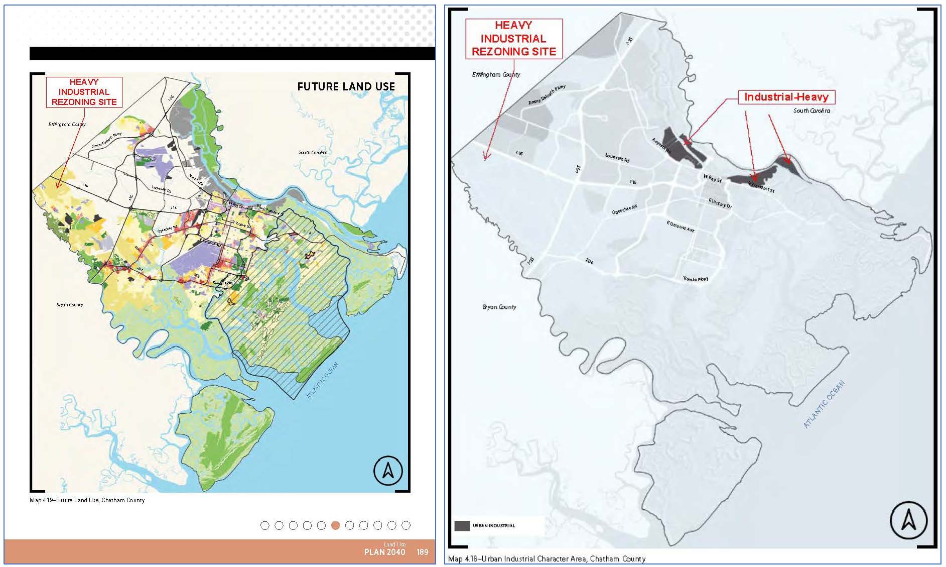
The future land use color coding for the heavy industrial rezoning site corresponds to Planned Development, which is mostly a mix of residential and retail commercial uses. The map on the right shows that the area slated for heavy industrial growth is quite some distance from the rezoning site. Obviously a very sweeping revision of the Savannah comprehensive plan is needed before any major rezonings (or annexations) should be considered.
Protest Petitions – A Vital Option
A number of states and localities allow the filing of a protest petition by those concerned about annexation, rezoning, conditional use or special exception permits. This action can be critical to winning annexation battles. The protest petition requires a super majority vote by the town or city council to approve the applicant’s request. In other words, to approve the application two-thirds or three-fourths of the members of the town board or county council must vote in favor. Otherwise an application can be approved with a simple majority.
Though the requirements vary, usually a minimum percentage of those owning property within a set distance of the site must sign a petition with a specific format then file it a set number of days prior to a hearing or other event. So, your first step should be to determine if the protest petition option is available then make certain you meet all the requirements.
Protest petitions are but one of many steps essential to winning annexation battles. However, because protest petitions are frequently key to success, we opted to bring it to your attention here. Keep in mind though that a protest petition is but one of a number of steps to victory. The other steps are described in our free 300-page book, How To Win Land Development Issues, and in the other web pages listed in the right column at the top of this page. If you lack the time to read through all these materials then consider retaining CEDS to carry out an Initial Strategy Analysis, which frequently leads to success at a far lower cost than simply hiring an attorney.
Deannexation – Reversing Past Annexations
According to a U.S. Census Bureau summary, most states allow a municipality to reverse a past decision to annex land. This process is generally known as deannexation.
As with annexation, most states require a solid factual basis for deannexation, notification of affected property owners, then hearings before a planning commission then the Town or City Council. As with annexation, winning a deannexation is usually 80% political, 10% factual and 10% legal. Frequently, deannexation occurs after an election where pro-growth incumbents are replaced with pro-community challengers.
Additional Annexation Information Sources
Following are websites and other sources of information regarding getting the benefits of annexation without causing harm to existing neighborhoods and communities: